Singletrack Sidewalks (STS)
Consultation has concluded
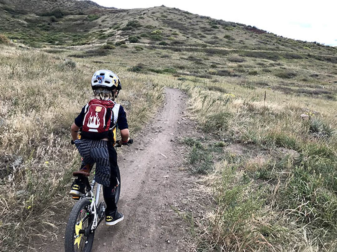
The Golden Giddyup, a local non-profit focused on trail stewardship in the Golden area, has proposed a new project for riders of all ages in the Golden community. This project would build single-track sidewalks - natural surface trails - next to existing paved bike paths to provide a place for young and beginner riders to experience mountain biking, although the trails would not be exclusively limited to beginner riders.
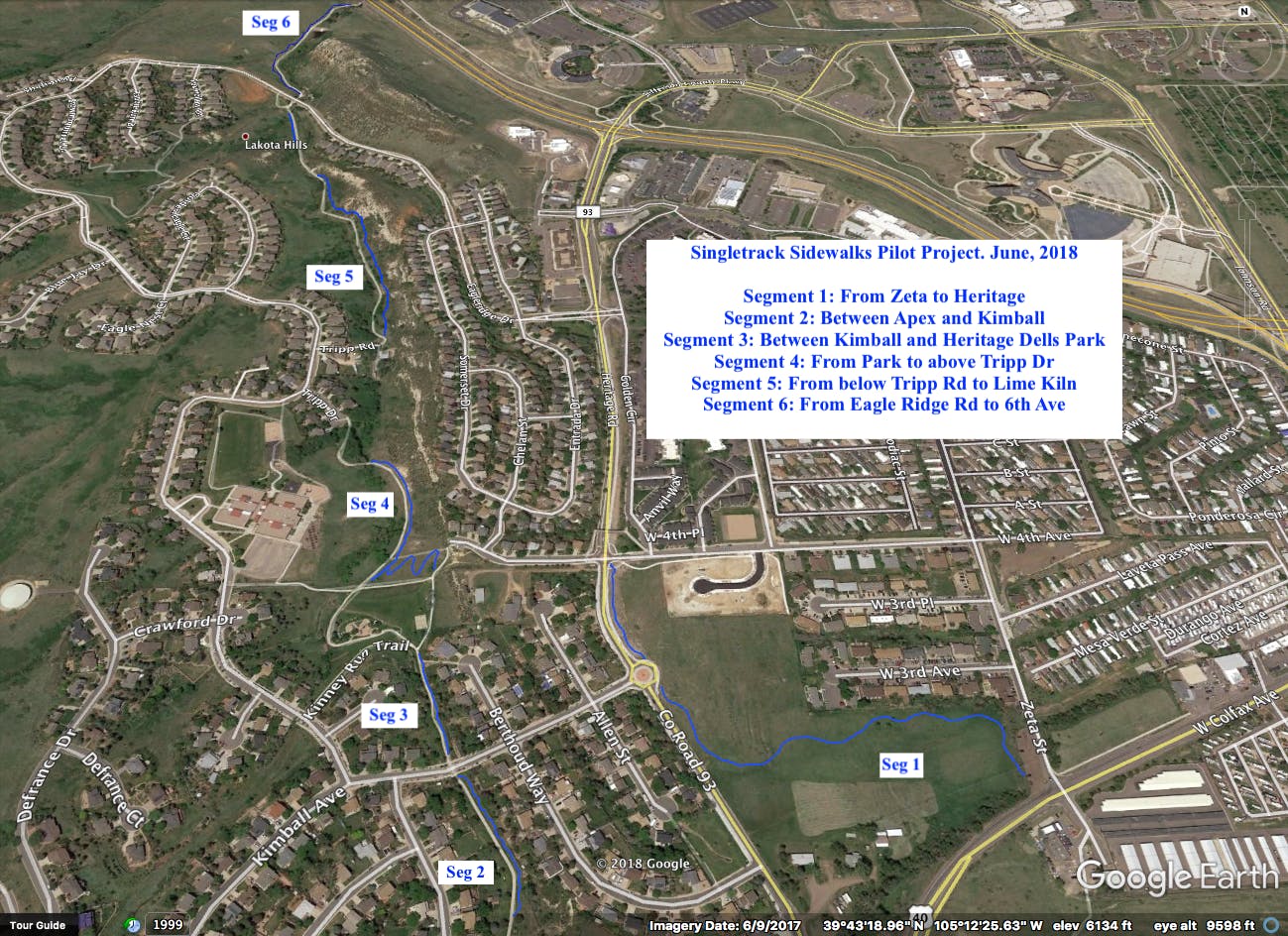
The proposed Singletrack Sidewalks pilot project (STS) would stretch from Apex Park to 6th Avenue along the bike path on city property. This pilot would be constructed by the Golden Giddyup Trail Team in partnership with neighborhood organizations and the City of Golden Parks staff.
The City of Golden is interested in gathering input from the community for this endeavor PRIOR TO taking any action. Please read the Golden Giddyup's updated full proposal and the supporting information provided on these pages, including detailed descriptions and maps of each proposed trail segment, then tell us what you think!
In order to provide additional information requested by interested citizens, City staff has recently added links to 22 documents in the Project Proposal & Supporting Documents section of this page. These documents contain minutes of Board meetings and staff reports that show the history of this proposed project. We encourage everyone to provide comments here, on the Guiding Golden webpage.
-
Trail Segment 1: Connecting Heritage Rd, 4th Avenue and Zeta Street
Share Trail Segment 1: Connecting Heritage Rd, 4th Avenue and Zeta Street on Facebook Share Trail Segment 1: Connecting Heritage Rd, 4th Avenue and Zeta Street on Twitter Share Trail Segment 1: Connecting Heritage Rd, 4th Avenue and Zeta Street on Linkedin Email Trail Segment 1: Connecting Heritage Rd, 4th Avenue and Zeta Street link
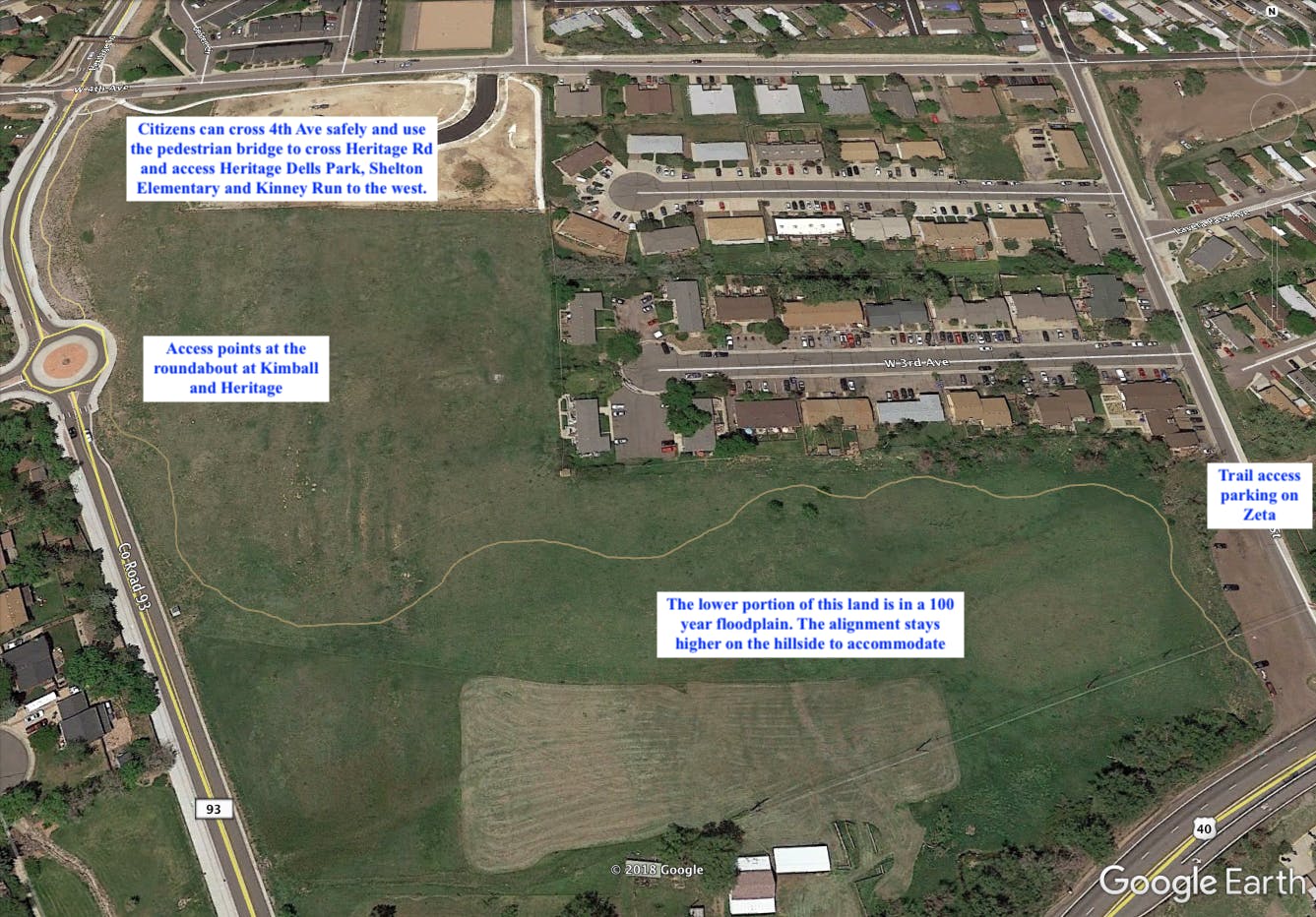
The first segment of the proposed pilot project was encouraged by Mayor Marjorie Sloan, offering a connection to the communities and neighborhoods east of Heritage Rd and over to Zeta St. This area has several social trails already existing, and an old road bed cutting through the lower lying areas. The alignment provides an access point at 4th and Heritage, adjacent to the pedestrian bridge over Heritage, as well as access points at the roundabout at Kimball and Heritage. As the trail heads east towards Zeta St, we have chosen to keep the alignment as high on the hillside as possible, as the lowest parts of this property are in a 100 year flood plain. Finally, the eastern access point would climb gradually out to the existing parking area on Zeta St, making this a convenient starting/ ending point.
Like the majority of segments, this has very little elevation gain or loss and is an excellent opportunity to create fun, flowy trail that would appeal to novices on up, and serve as a safe alternative connecting communities east of Heritage Rd to the Kinney Run bike path, Shelton Elementary School, Heritage Square, and other local amenities.
Total mileage: .28 miles

-
Trail Segment 2: Between Kimball and Apex Park
Share Trail Segment 2: Between Kimball and Apex Park on Facebook Share Trail Segment 2: Between Kimball and Apex Park on Twitter Share Trail Segment 2: Between Kimball and Apex Park on Linkedin Email Trail Segment 2: Between Kimball and Apex Park link
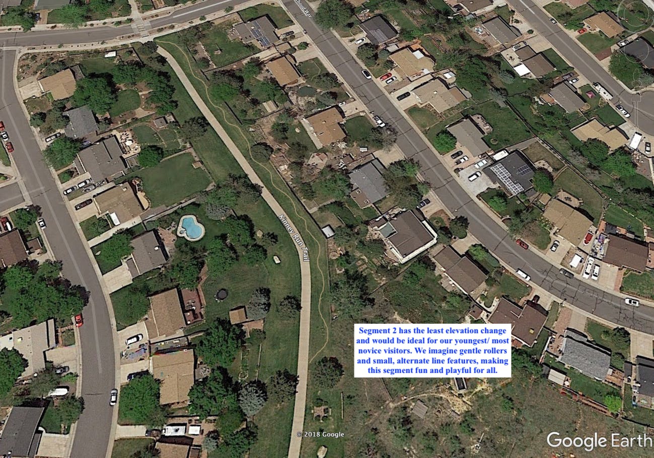
Starting just north of the Apex trailhead and .1 miles south of Kimball street, this segment has some of the least elevation gain/ loss and would be ideal for young balance bikers, Strider riders and those first putting tires on dirt. Golden Giddyup imagines this alignment to have subtle rollers and gently curve back and forth through the landscape, "giving visitors just a taste of fun and skill development in a very safe environment."
Total Mileage: .1 miles

-
Trail Segment 3: Between Kimball and Heritage Dells Park
Share Trail Segment 3: Between Kimball and Heritage Dells Park on Facebook Share Trail Segment 3: Between Kimball and Heritage Dells Park on Twitter Share Trail Segment 3: Between Kimball and Heritage Dells Park on Linkedin Email Trail Segment 3: Between Kimball and Heritage Dells Park link
Segment 3 begins at Kimball and heads north towards Heritage Dells Park, along the greenway. Similar to Segment 2, there is little elevation loss and this segment offers opportunities for beginning bikers to play on natural surface trails in a safe, controlled environment.
Total Mileage: .1 miles

-
Trail Segment 4: Between Heritage Dells Park and Crawford Circle
Share Trail Segment 4: Between Heritage Dells Park and Crawford Circle on Facebook Share Trail Segment 4: Between Heritage Dells Park and Crawford Circle on Twitter Share Trail Segment 4: Between Heritage Dells Park and Crawford Circle on Linkedin Email Trail Segment 4: Between Heritage Dells Park and Crawford Circle link
Segment 4 has two components.
The upper component would consist of a series of broad, stacked switchbacks with subtly insloped turns. The primary goal here is to keep riders away from the playground at Heritage Dells Park. Local residents have often expressed concerns about cyclists riding (often at great speed) on the Kinney Run bike path next to the playground where small children are often playing. Our objective would be to encourage traffic to stay on the path above (to the east) of the park, and re-joining the natural surface trail on top of the slope, avoiding traffic around and through the park altogether.
The lower trail next to Kinney Run bike path has very little elevation change and would be accessible to Strider riders on up.
Total Mileage: .23 miles

-
Trail Segment 5: Between Tripp Ranch Dr. and the Historic Cambria Lime Oven
Share Trail Segment 5: Between Tripp Ranch Dr. and the Historic Cambria Lime Oven on Facebook Share Trail Segment 5: Between Tripp Ranch Dr. and the Historic Cambria Lime Oven on Twitter Share Trail Segment 5: Between Tripp Ranch Dr. and the Historic Cambria Lime Oven on Linkedin Email Trail Segment 5: Between Tripp Ranch Dr. and the Historic Cambria Lime Oven link
Segment 5 is one of the most beautiful and interesting segments of this project. Beginning where the Kinney Run bike path re-starts below Tripp Ranch Rd, the alignment follows existing social trails and stays just above the bike path on what appear to be man-made terraces likely from the ranching days. The trail would touch on rock outcroppings and create excellent opportunities for skills development with gentle rollers and slightly more elevation change than the other segments.
The northern access point of this segment would be respectfully south of the lime oven historic site that is adjacent to the Kinney Run bike path.
Total Mileage: .29 miles

-
Trail Segment 6: From Eagle Ridge Rd to above 6th Avenue underpass
Share Trail Segment 6: From Eagle Ridge Rd to above 6th Avenue underpass on Facebook Share Trail Segment 6: From Eagle Ridge Rd to above 6th Avenue underpass on Twitter Share Trail Segment 6: From Eagle Ridge Rd to above 6th Avenue underpass on Linkedin Email Trail Segment 6: From Eagle Ridge Rd to above 6th Avenue underpass link
The final segment poses the least impact to nearby residences and developments. The alignment could veer the farthest from the path (though staying within 20-30’ from Kinney Run), getting up into some of the gentle hillsides on the west of the corridor. Similar to other segments, there is little elevation change, offering great opportunities for all levels of visitors.
Total Mileage: .26 miles